PhotoViz a concept by Nicholas Felton
“PhotoViz argues that in a world overwhelmed with both data and photography, there is an increased need for both aggregating photos and for making data stories more evocative. This collection is composed of projects based on photography that demonstrate patterns, reveal the invisible and tell more descriptive stories than either traditional photography or dataviz.”
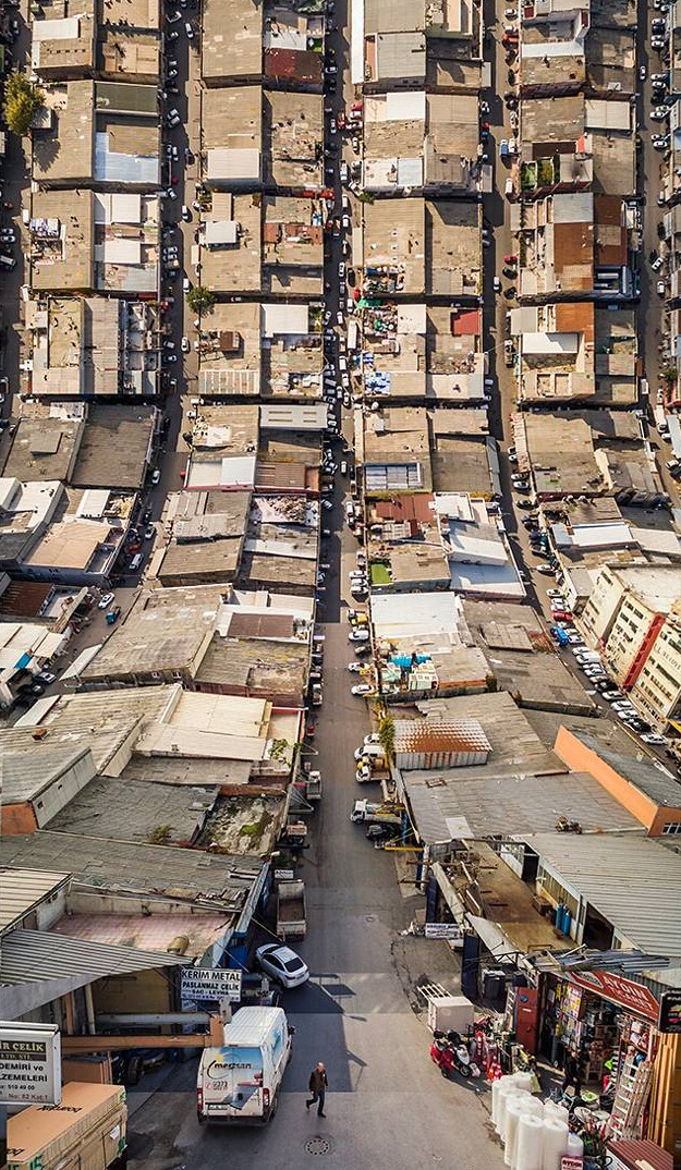
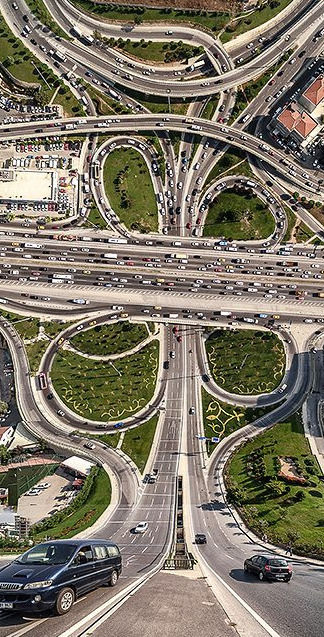
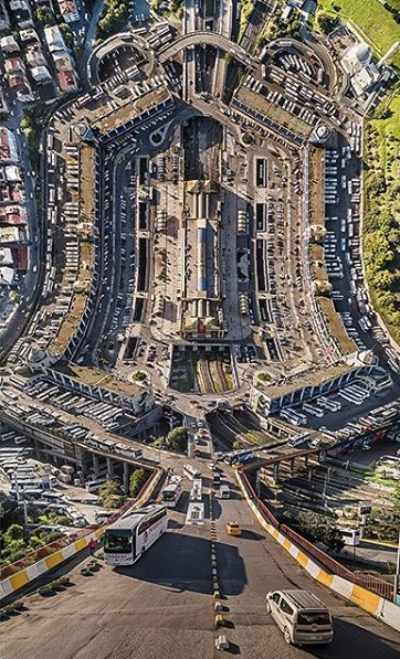
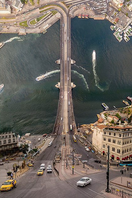
Inception ala Istanbul, Aydın Büyüktaş
Visual effects artist Aydin Buyuktas uses photography to recreate images from his dreams. Shooting cityscapes from above, he then digitally bends them toward the sky in photos reminiscent of the movie “Inception.”
The resulting photo series, “Flatlands,” uses these surreal, digitally-manipulated scenes to warp the viewer’s sense of time and space, Buyuktas said in an email interview.


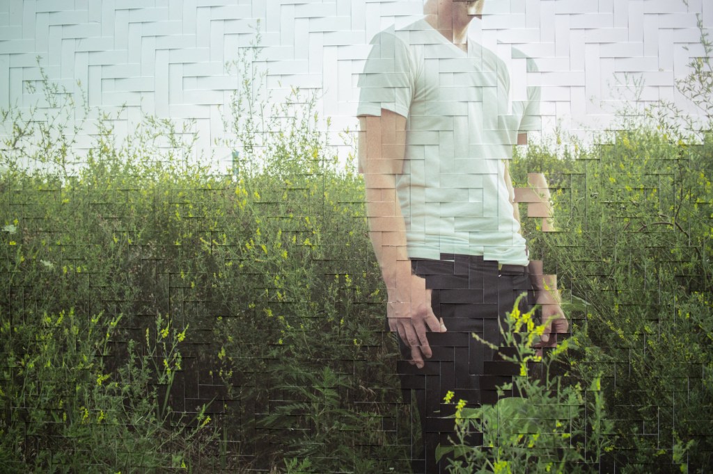
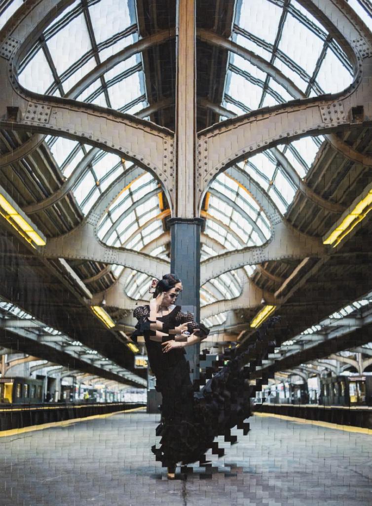
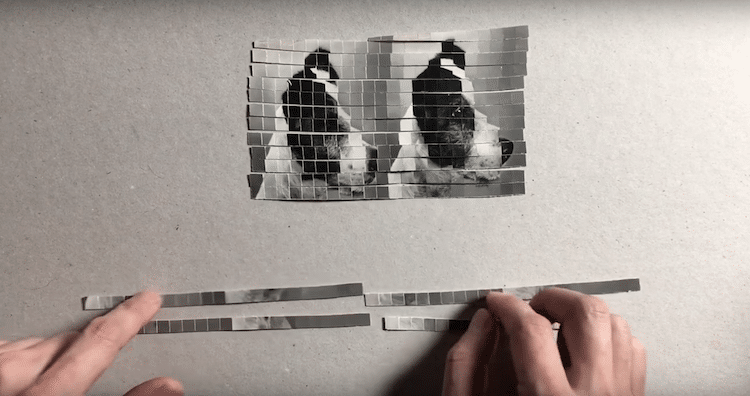
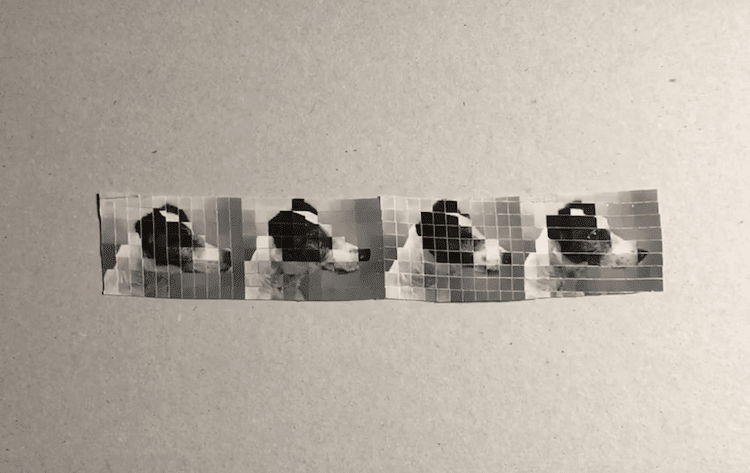
Woven photography by Jason Chen


Pelle has been making work for an ongoing series, Crowded Fields, composing images which see your average diving competition, hockey game or tennis match repeating until they fill his frame with frenzy. Describing the project as “the sports department” of his wider street photography portfolio, Pelle’s practice sees him arranging photographs that have “dozens of moments instead of just the one”.


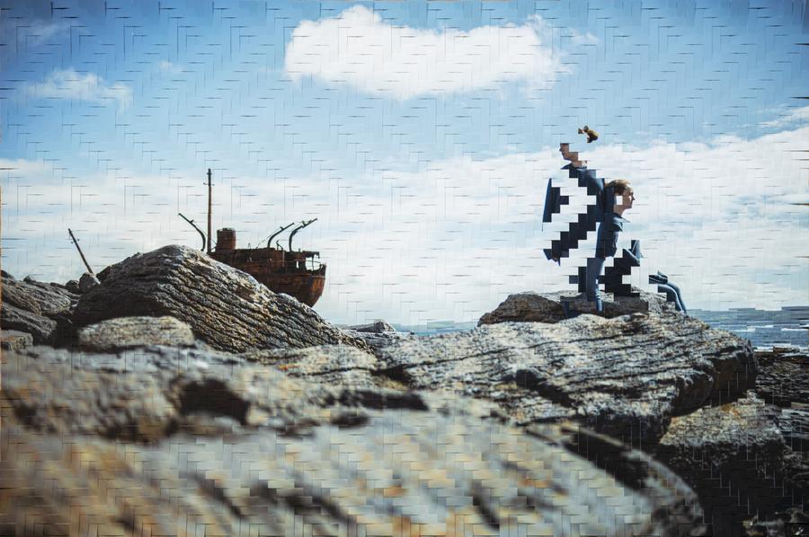
2018 Winter Olympic photoviz by The New York Times


Panopanic Instagrams by Able Paris


iOS Maps Glitches by Peder Norrby
Trapcode founder Peder Norrby has produced a photography series on iOs Maps and malfunctioning algorithm’s that have occurred whilst visually documenting our beautiful planet
https://www.itsnicethat.com/articles/google-earth-glitches?


Xavi Bo – Ornitographies
Xavi Bou focuses on birds, his great passion, in order to capture in a single time frame, the shapes they generate when flying, making visible the invisible.
Unlike other motion analysis which preceded it, Ornitographies moves away from the scientific approach of chronophotography used by photographers like Eadweard Muybridge and Etienne-Jules Marey.


Horizons by Michael Kontopoulos
A video installation in which horizon shots from various Samurai and Spaghetti Western films are stitched together to form one expanded environment.
This piece was first exhibited in a panoramic theater in the Carnegie Museum of Natural History.
In the aftermath of the Chernobyl and Fukushima nuclear disasters, millions were displaced, and once bustling communities became husks of their past selves. While the emptiness of these places is plain to see, radiation, the reason why so many choose not to return to areas declared safe by authorities, is invisible.
In areas of Russia and Japan that have been decontaminated by the government, allowing for people to move back, life has tried to continue but evidence of radiation remains. Greg McNevin, a photographer working with the environmental group Greenpeace, set out to visualize the radiation that persists in many of these areas. The resulting project juxtaposes radiation data onto long exposure photographs from the affected regions.


Timo Arnall, Light Painting WiFi
In his piece Immaterials, the artist Timo Arnall uses custom LED lights to visualize the strength of Wi-Fi signals in outdoor spaces. By using long-exposure photography to capture these visualizations, he creates “light paintings” of Wi-Fi networks in urban spaces
The city is filled with an invisible landscape of networks that is becoming an interwoven part of daily life. WiFi networks and increasingly sophisticated mobile phones are starting to influence how urban environments are experienced and understood. We want to explore and reveal what the immaterial terrain of WiFi looks like and how it relates to the city.

Berg: Immaterials: Light Painting WiFi
ARCHIVES
the Teenie Harris Archive
Charles “Teenie” Harris (1908–1998) was the preeminent photographer for The Pittsburgh Courier, one of the nation’s most prominent Black newspapers photographing Pittsburgh’s historic African American community from 1935 to 1975. His archive of over 70,000 images is one of the most detailed and intimate records of the Black urban experience known today.
Studio 24/24: jasminedeporta.com
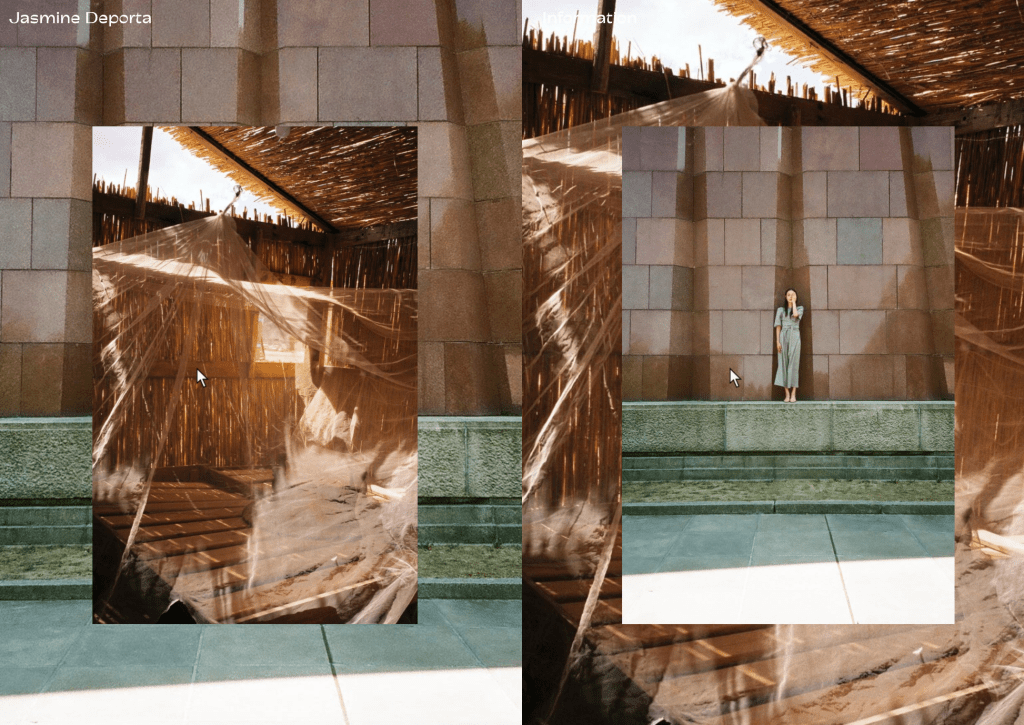
As you click, the images on the site cycle through, appearing once on each side, once as a background image and once in a smaller size at their true ratio. To view each image full-size, or in isolation, you can simply hover over the small square at the bottom of the screen.
JENNY ODELL
Jenny Odell, a San Francisco-based artist who collects Google Maps images of inanimate structures and arranges them on blank backgrounds.
https://www.businessinsider.com/google-maps-as-art-jenny-odell-2013-7#stadiums-11
https://www.jennyodell.com/signsoflife.html


Land Lines By Zach Lieberman & Data Arts Team at Google
Land Lines lets you explore Google Earth satellite images through gesture. Machine learning and line detection algorithms were used to preprocess all images and identify the dominant lines. This enabled the analysis of brushstrokes and retrieval of the matching image efficiently without the need for a server.The project was made in collaboration by Zach Lieberman and the Data Arts Team.

https://lines.chromeexperiments.com/
SLIT SCANNING
Slitscan imaging techniques are used to create static images of time-based phenomena. In traditional film photography, slit scan images are created by exposing film as it slides past a slit-shaped aperture. In the digital realm, thin slices are extracted from a sequence of video frames, and concatenated into a new image.
https://editor.p5js.org/codingtrain/sketches/B1L5j8uk4
Bryan Mumford Streak Photography (2000’s)
“The image shown here is what I started with: an iris in a bottle. The bottle is sitting on a rotary table. The rotary table is computerized and can be instructed to move by specific amounts. The Time Machine’s flash output is used to trigger motion in the rotary table. The procedure is as follows: 1) take a picture of the iris 2) rotate the flower 1.8 degrees 3) take another picture. This process is repeated over and over until 500 to 800 pictures have been taken from all different angles.”

Camille Utterback Liquid Time (2000)
Utterback writes: “In the Liquid Time Series installation, a participant’s physical motion in the installation space fragments time in a pre-recorded video clip. As the participant moves closer to the projection screen they push deeper into time—but only in the area of the screen directly in front of them. To create this imagery Utterback’s software deconstructs the video frame as the unit of playback. This piece destabilizes a basic premise of time based media—that the unit of recording is also the unit of playback.”

Michael Aschauer Danube Panorama Project (2005)
A comprehensive slit-scan panorama of the entire Danube river coastline. Every strip in the panorama is indexed by its latitude and longitude, derived from GPS, thus permitting the images to be situated and browsed with an unusual quality and degree of geographic precision. Aschauer writes: “The Danube Panorama Project is an experimental approach in fotographic mapping and cartography. Its vision is to produce a full panorama of the Danube’s river sides by digitally Slit-scanning its Coastlines, resulting in a unique ‘cross section’ of Europe. The Danube – ‘Europe’s River of Destiny’ – which like nothing else is connecting Western, Middle and Eastern Europe and which like nothing else reflects the inconsistent relationships of its peoples, cultures and religions by all its historic and current functions, will guide as a symbolic red line of this fotographic survey.”

Romy Achituv with Michael Naimark et al.
Be Now Here [Interactive] (1997)
Achituv writes: “The Be Now Here Interactive application is an experiment in imbedding a moving video image within a larger static visual context. It is also a prototype for an alternative structure for non-linear cinematic narrative. As the active video window moves across the screen it leaves a visual trail, which is a trace of the time and space of the cinematic path. The user can maneuver back and forth through each scene creating and erasing moments in time, laying down a panoramic still that also represents a captured slice of time, then returning to view the scene unfold and come alive. The application demonstrates the possibility for separating and independently controlling spatial and temporal cinematic elements within one narrative space. This application was created with footage shot by Michael Naimark and Interval Research Corp. for Naimark’s Be Now Here installation (1996).”

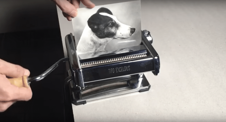
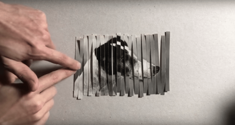
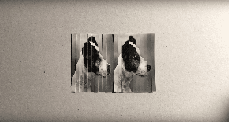
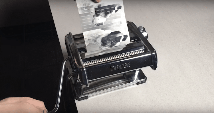
Kensuke Koike crafts collage
To make his work, Kensuke Koike first puts a photo through a pasta maker.
Painting Lesson: Sunrise on a Lake
https://www.tiktok.com/embed/v2/6885607038601202949?lang=en-US
PLATFORM “COLLABORATIONS”
Strava
Strava’s online exercise-tracking map unwittingly reveals remote military outposts — and even the identities of soldiers based there. The situation shows how data collection can lead to unintended consequences
dick_run_claire
https://www.instagram.com/dick_run_claire/
This woman has been running around the world drawing male genitalia with her GPS recordings of her runs via Nike’s running app

“Street With A View” 2008 Robin Hewlett and Ben Kinsley
On May 3rd 2008, artists Robin Hewlett and Ben Kinsley invited the Google Inc. Street View team and residents of Pittsburghs Northside to collaborate on a series of tableaux along Sampsonia Way. Neighbors, and other participants from around the city, staged scenes ranging from a parade and a marathon, to a garage band practice, a seventeenth century sword fight, a heroic rescue and much more…
Street View technicians captured 360-degree photographs of the street with the scenes in action and integrated the images into the Street View mapping platform. This first-ever artistic intervention in Google Street View made its debut on the web in November of 2008.


“Women Laughing Alone With Salad” Edith Zimmerman
Women Laughing Alone With Salad is a single topic blog specifically devoted to curating stock photographs of women laughing and eating salad. Since its launch in January 2011, the stock photo cliché has become a popular subject of parodies and satires regarding the stereotypical portrayal of women in media.


Exhausting a Crowd by Kyle Mcdonald
In 1974, French writer Georges Perec spent three days on a bench in Saint-Sulpice Square in Paris, writing about 60 pages on the minutiae that usually goes overlooked, from the people walking by to the details of the architecture. His “An Attempt at Exhausting a Place in Paris” is part of the inspiration behind Kyle McDonald’s new online interactive Exhausting a Crowd. Twelve hours of footage from two days at London’s busy Piccadilly Circus is open to annotation, where anyone online can comment on the happenings and people in an accumulating experiment in surveillance and how human intelligence can be enhanced through automation.


https://www.exhaustingacrowd.com/beijing
I’m Google by Dina Kelberman (ongoing)


https://dinakelberman.tumblr.com/
“Drone Attack” 2019 JASon ISOlini
Uploaded To Google Maps At 77 Mulberry Street For “Perma Falling” Curated By Joshua Citarella.

Uploaded To Google Maps At 77 Mulberry Street For “Perma Falling” Curated By Joshua Citarella.

https://www.vice.com/en/article/d3nedw/this-artist-hacking-google-to-create-surreal-street-view-art
UNLIKELY CAPTURE APPARATUSES
Corneal Imaging

Images of what someone is looking at can be recovered from reflections in their eyes. See: Ko Nishino et al., “Corneal Imaging System: Environment from Eyes”. Corneal imaging
A Camera Drama – Workshop with Roel Wouters
ECAL Media & Interaction Design + ECAL Industrial Design
Workshop led by the dutch designer Roel Wouters – Moniker. Projects realised by the students in Media & Interaction Design in collaboration with the Industrial Design students.
Brief: Build an apparatus that produces videos the world has never seen before.
Take Spinning Video Footage from Above with a Ceiling Fan & Phone
GOpro on a Tuba
Polluted Water Popsicles by Hung I-chen, Guo Yi-hui and Cheng Yu
Made from sewage found in Taiwan’s polluted rivers, these inedible suckers were made to serve as a commentary on the island nation’s rising water pollution and its deep effect on the world’s population.
Created by three students – Hung I-chen, Guo Yi-hui and Cheng Yu-ti – from the National Taiwan University of the Arts, these ‘Polluted Water Popsicles’ effectively illustrate a vital environmental issue that can easily go unnoticed. Their work takes this concern and gives it concrete visibility; plastics, metals, and other harmful pollutants are clearly seen when one peers closely at the popsicles.


Curated “memories” in photos
Reverse google image search
“Similar” images

Leave a comment